Adriatic Sea and Coast (AdriSC) Meteotsunami Forecast - Help and About
Introduction
The Adriatic Sea and Coast (AdriSC) Meteotsunami Forecast is a research product that was developed within the framework of two Croatian research projects: (1) project MESSI (http://www.izor.hr/messi), for reproduction and forecast of the Adriatic meteotsunamis, being a part of a pilot meteotsunami early warning system and (2) project ADIOS (http://www.izor.hr/ADIOS), with an ongoing effort to better understand the interactions between the Ionian and Adriatic Seas over interannual to decadal timescale and their potential effects on the ocean circulation along the Croatian coastline and islands.
Two different AdriSC modules have been developed: (1) a basic module using the COAWST model with WRF (3km highest resolution) for the atmosphere and ROMS (1km highest resolution) for the ocean (in blue in the figure) and (2) a dedicated meteotsunami module using WRF (1.5km resolution) for the atmosphere and ADCIRC (between 10m and 5km) for the ocean (in red in the figure).
- 48h forecast of hourly atmospheric fields from the WRF model: air temperature at 2m (°C), air temperature at 850 mbar (°C), mean sea level air pressure (hPa), wind at 10m (m/s), wind at 500mbar (m/s), cloud coverage (%) and rain (mm per hour). The WRF results presented in the website have a spatial resolution of 3km and thus cannot provide accurate fields at precise locations.
- 48h forecast of hourly ocean fields from the ROMS model: sea surface elevation (m, including tides), sea surface ocean currents (cm/s), barotropic ocean currents (cm/s, averaged value of the currents over the depth), sea surface ocean temperature (°C), salinity, significant wave height (m), wave period, wave length and wave direction. The ROMS results presented in the website have a spatial resolution of 1km and thus cannot resolve all the geographic features of the numerous Croatian Islands bays and harbors.
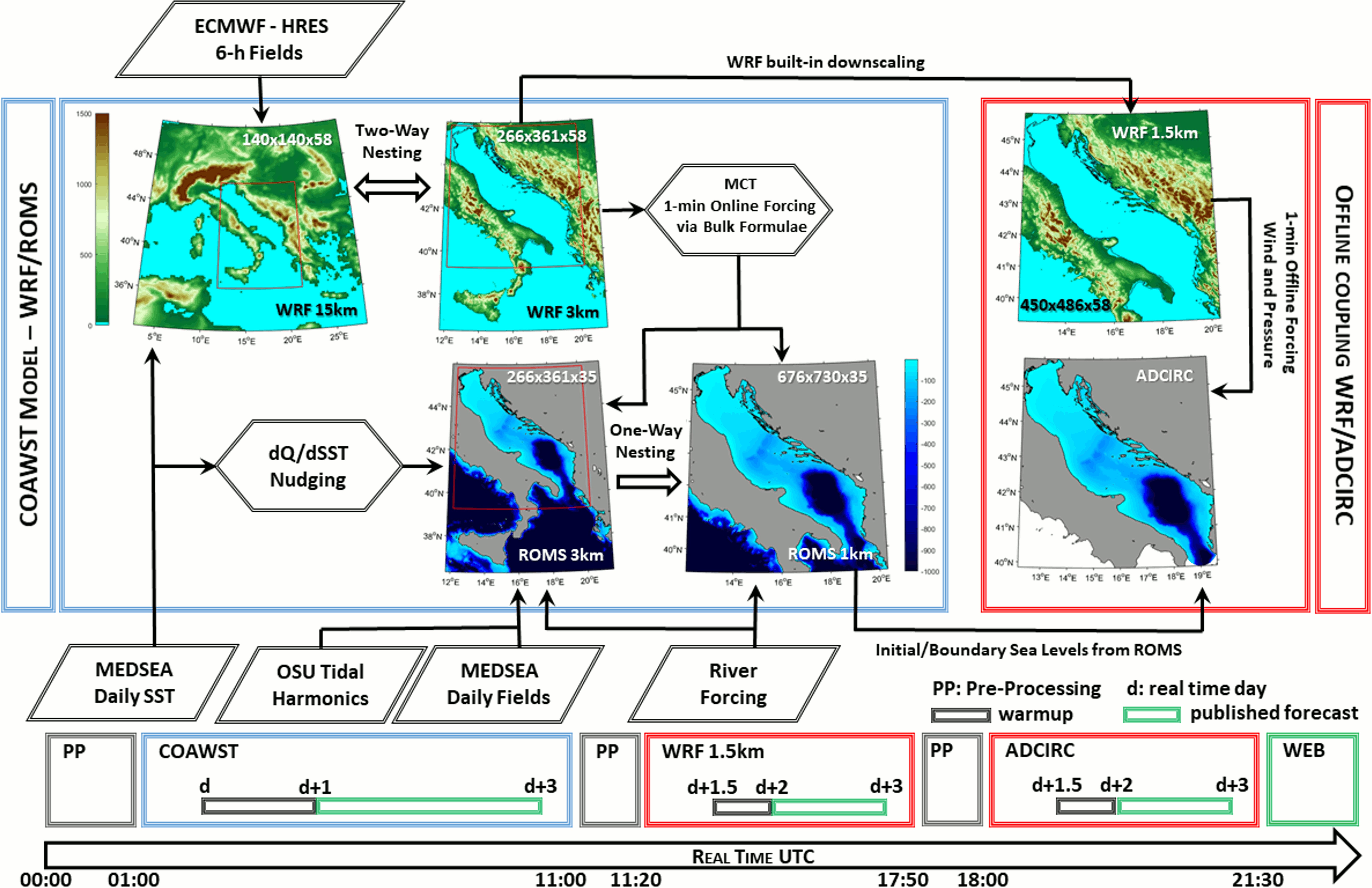
Figure 1.Operational mode of the AdriSC Meteotsunami Forecast component. On the top, the flow chart represents the coupling between the different models (in blue COAWST, in red WRF/ADCIRC), their grids (plotted with topography/bathymetry data) and their forcing. On the bottom the timeline shows the different steps of the operational run starting every day d at 00:00 UTC (real time) and running from day d to day d+3. The forecast data is published on the web (in green) for days d+1 to d+3.
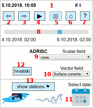
- Scene header. Left is date and time of current scene, right is control for show/hide controls.
- Shift to previous scene. From present time and for last 3 days scene shift is one hour. For scenes more then 3 days ago, scene shift is 6 hours.
- Shift to next scene. (1 hour for recent and 6 hours for more then 3 days old scenes).
- Start/Stop animation. Animation automatically shift scenes. In case of slow connection and/or vector layer can be out of synchronization.
- Zoomed area details / less details. When You zoom to area small enough this button becomes enabled. With this button You can reload data for zoomed area containing full data resolution and with customized range. Click again returns averaged fields.
- Reset map. This button reset map to initial zoom and position.
- Help and About. This button shows this page with page detailed explanations.
- Scene slider. With slider user can easy change scene from begin to end of each run (from begin of current day to end of day after tomorrow).
- Select scalar layer
- Select vector layer
- Choose day of previous model runs.
- Switch interface language to Croatian
- Show/Hide model stations. Model station are locations with model miute values. If there is also actual measuring station on same location, marker on the map is bigger. Meaning of marker codes: W - WRF model (meteorogical values), R - ROMS model (oceanographic values), A- ADCIRC model (sea level), M- measurements avaliable.
Description of the modules
1. Basic module
The basic module domains are presented in Figure 1 (blue box) and are defined as follow: a 15km grid (horizontal size: 140 x 140) for the atmospheric model, approximately covering the central Mediterranean basin, and a nested 3km atmospheric grid (266 x 361) encompassing the entire Adriatic and Ionian Seas; the same 3km grid is used for the ocean model with a nested additional 1km grid (676 x 730) allowing for better representation of the complex geomorphology of the Adriatic Sea and most particularly of the Croatian coast. The vertical discretization of the grids is achieved via terrain-following coordinates: 58 levels refined in the surface layer for the atmosphere (Laprise, 1992) and 35 levels refined near both the sea surface and bottom floor for the ocean (Shchepetkin, 2009). Additionally, the basic module is using a common tidal and river forcing for the ocean grids. Eight tidal constituents (M2, S2, N2, K2, K1, O1, P1, Q1) – extracted from the Mediterranean and Black Seas (2011) 1/30° regional solution of the OSU Tidal Inversion Software (OTIS – Egbert, Bennett, and Foreman,1994; Egbert and Erofeeva, 2002), are imposed on the offshore boundaries of the 3km grid. These constituents are found to satisfactorily reproduce tidal dynamics in a micro-tidal Adriatic Sea (Cushman-Roisin and Naimie, 2002; Janeković and Kuzmić, 2005).
A total of 54 river flows (49 for the 1km grid) are imposed over at least 6 grid points each (18 grid points for the Po river delta), with river mouths located along the coastline of Greece, Albania and Montenegro, Croatia and Slovenia, Italian peninsula and Sicily. The river flow monthly climatology is based on the RivDis database (Vörösmarty et al., 1996), and studies from Malačič and Petelin (2009), Pano and Avdyli (2002), Pano et al. (2010), Janeković et al. (2014) and Ljubenkov (2015). The interannual variability of the flows is derived from Ludwig et al. (2009).
The basic module of the AdriSC modelling suite is based on a modified version of the Coupled Ocean-Atmosphere-Wave-Sediment-Transport (COAWST V3.3) modelling system developed by Warner et al. (2010), which couples (online) the Regional Ocean Modeling System (ROMS svn 885) (Shchepetkin & McWilliams, 2005, 2009) and the Weather Research and Forecasting (WRF v3.9.1.1) model (Skamarock et al., 2005) via the Model Coupling Toolkit (MCT v2.6.0) (Larson et al., 2005) and the remapping weights computed – between the 15km, 3km and 1km atmospheric and ocean grids, with the Spherical Coordinate Remapping and Interpolation Package (SCRIP).
2. Meteotsunami module
For the meteotsunami module, in order to properly represent the meteotsunami genesis and propagation, two additional grids are used (Figure 1, red box): a 1.5km grid (450 x 486) for the atmosphere and an unstructured mesh for the ocean, with a resolution ranging from about 5km in the deepest part of the Adriatic to 10m in the locations where harbor resonance is known to occur (286336 nodes, 513340 triangular elements with 477 islands and islets included). Conjointly to the COAWST model (used in the basic module), the meteotsunami module is thus coupling (offline) the WRF model (1.5km grid) with the barotropic version (2DDI) of the unstructured ADvanced CIRCulation (ADCIRC v52.30) model (Luettich et al., 1991).
- 24h forecast of 15-min atmospheric fields from the WRF model at 1.5km spatial resolution provided in specific areas: air temperature at 2m (°C), air temperature at 850 mbar (°C), mean sea level air pressure (hPa), wind at 10m (m/s) and wind at 500mbar (m/s).
- 24h forecast of 15-min atmospheric fields from the ADCIRC model at high spatial resolution provided in specific areas: sea surface elevation (including tides) and barotropic ocean currents (i.e. averaged value of the currents over the depth).
AdriSC Meteotsunami Forecast Operational Mode
Since the 1st of March 2018, the AdriSC Meteotsunami Forecast runs operationally every day at midnight (UTC) in two different steps (Figure 1). First, the COAWST model (basic module) – exchanging WRF fields with ROMS grids every minute, is used to generate hourly outputs for the next three day period with the initial state and boundary conditions provided: (1) 6-hourly to the WRF 15km grid by the previous day 12 UTC based analysis of the ECMWF Atmospheric Model high resolution (0.1° x 0.1°) 10-day forecast (HRES – Lalaurette, 2002; Tsonevsky and Richardson, 2012; Petroliagis and Pinson, 2012; Zsótér, 2006; Zsótér et al., 2014), and (2) daily to the ROMS 3km grid by the Mediterranean Forecasting System (MFS) high resolution (1/24° x 1/24°) 10-day MEDSEA forecast (Pinardi et al., 2003; Pinardi and Coppini 2010; Tonani et al 2014). Second, the meteotsunami module runs for a 36h-period beginning a day and half after the start date of the COAWST model run: the hourly WRF 3km results are downscaled to the WRF 1.5km grid and the hourly ROMS 1km sea surface elevation results are imposed as initial state and boundary conditions to the ADCIRC model. The WRF model then runs for the single 1.5km grid and provides 1-min outputs that, at the end of the simulation, are used as atmospheric forcing in the ADCIRC model.
The choice of starting the COAWST model run 12h after the latest HRES analysis (12 UTC based) is principally driven by the need to produce at least a two-day short-term forecast in less than 24h staring from 19:00 UTC, when the HRES results are theoretically available, but also by the fact that some warmup period is needed to adjust the physics of the models to the analysis (or more generally the initial condition). For the AdriSC Meteotsunami Forecast component, this warmup period is assumed to be of 1 day for the COAWST model (basic module) and 12h for the offline coupling of WRF 1.5km and ADCIRC (meteotsunami module).
A conservative estimate of the running times of the different modules of the AdriSC Meteotsunami Forecast component is as follow (Figure 1): 1h to download and format the ECMWF and MEDSEA forecast fields, 10h to run the COAWST model, 20min to downscale the WRF 3km results to the 1.5km grid and to produce the initial/boundary conditions of the ADCIRC model from the ROMS 1km results, 6h30 to run the WRF 1.5km grid, 10min to generate the ADCIRC atmospheric forcing and 3h30 to run the ADCIRC model. At the end of every day, the next 48h hourly-forecast results from the COAWST run, as well as the 15min-forecast results from WRF 1.5km and ADCIRC simulations for the next day, are downloaded in a database and published at: http://faust.izor.hr/autodatapub/adrisc?jezik=eng.
Development and contact
Cléa Denamiel
Model results database loading, model visualization (web page):
Damir Ivanković
adrisc@izor.hr
References
- Cushman-Roisin, B., Naimie, C. E. (2002). A 3d finite-element model of the Adriatic tides. J. Mar. Syst. 37, 279–297.
- Egbert, G.D. and Erofeeva, S.Y. (2002). Efficient inverse modeling of barotropic ocean tides, J. Atmos. Ocean. Tech., 19, 183 – 204.
- Egbert, G. D., Bennett, A. F., Foreman, M. G. G. (1994). Topex/Poseidon tides estimated using a global inverse model, J. Geophys. Res., 99, 24,821 – 24,852.
- Janeković, I., Mihanović, H., Vilibić, I., Tudor, M. (2014). Extreme cooling and dense water formation estimates in open and coastal regions of the Adriatic Sea during the winter of 2012. Journal of Geophysical Research, 119, 3200-3218, doi:10.1002/2014JC009865
- Lalaurette F. 2002. Early detection of abnormal weather conditions using a probabilistic extreme forecast index. Q. J. R. Meteorol. Soc. 129: 3037–3057.
- Laprise R. (1992). The Euler Equations of motion with hydrostatic pressure as independent variable. Mon. Wea. Rev., 120, 197–207.
- Larson, J., Jacob, R., Ong, E. (2005). The Model Coupling Toolkit: A New Fortran90 Toolkit for Building Multiphysics Parallel Coupled Models. The International Journal of High Performance Computing Applications, 19 (3), pp 277-292. doi:10.1177/1094342005056115
- Ljubenkov, I. (2015). Hydrodynamic modeling of stratified estuary: case study of the Jadro River (Croatia). Journal of Hydrology and Hydromechanics, 63(1), 29-37, doi: https://doi.org/10.1515/johh-2015-0001
- Luettich, R.A., Birkhahn, R.H., Westerink, J.J. (1991). Application of ADCIRC-2DDI to Masonboro Inlet, North Carolina: A brief numerical modeling study. Contractors Report to the US Army Engineer Waterways Experiment Station, August, 1991.
- Ludwig, W., E. Dumont, M. Meybeck, and S. Heussner (2009). River discharges of water and nutrients to the Mediterranean Sea: Major drivers for ecosystem changes during past and future decades? Prog. Oceanogr., 80, 199–217, doi:10.1016/j.pocean.2009.02.001
- Malačič, V. and Petelin, B. (2009). Climatic circulation in the Gulf of Trieste (northern Adriatic). J. Geophys. Res., 114, C07002, doi:10.1029/2008JC004904.
- Pano, N. and Abdyli, B. (2002). Maximum floods and their regionalization on the Albanian hydrographic river network. International Conference on Flood Estimation. CHR. Report II,17 Bern, Switzerland, pp.379-388.
- Pano, N., Frasheri, A., Avdyli, B. (2010). The Climatic Change Impact in Water Potential Processe on the Albanian Hydrographic River Network. International Congress on Environmental Modelling and Software. 266. https://scholarsarchive.byu.edu/iemssconference/2010/all/266
- Petroliagis and Pinson, 2012. Early indication of extreme winds utilising the Extreme Forecast Index. ECMWF Newsletter 132, Summer 2012, pp 13–19.
- Pinardi, N., Allen, I., Demirov, E., De Mey, P., Korres, G., Lascaratos, A., Le Traon, P-Y., Maillard, C., Manzella, G. and Tziavos C. (2003). The Mediterranean ocean Forecasting System: first phase of implementation (1998-2001). Annales Geophysicae, 21, 3-20, doi:10.5194/angeo-21-3-2003.
- Pinardi, N. and Coppini, G. (2010). Operational oceanography in the Mediterranean Sea: the second stage of development. Ocean Science, 6, 263-267.
- Shchepetkin, A. F., and McWilliams, J.C. (2005). The regional oceanic modeling system: A split‐explicit, free‐surface, topography‐following‐coordinate ocean model. Ocean Modell., 9, 347–404.
- Shchepetkin, A. F., and J. C. McWilliams (2009). Correction and commentary for “Ocean forecasting in terrain‐following coordinates: Formulation and skill assessment of the regional ocean modeling system” by Haidvogel et al., J. Comput. Phys., 227, pp. 3595–3624. J. Comput. Phys., 228, 8985–9000. doi:10.1016/j.jcp.2009.09.002
- Skamarock, W. C., Klemp, J. B., Dudhia, J., Gill, D. O., Barker, D. M., Wang, W., Powers, J. G. (2005). A Description of the Advanced Research WRF Version 2. NCAR Technical Note NCAR/TN-468+STR, doi:10.5065/D6DZ069T.
- Tonani M., A. Teruzzi, G. Korres, N. Pinardi, A. Crise, M. Adani, P. Oddo, S. Dobricic, C. Fratianni, M. Drudi, S. Salon, A. Grandi, G. Girardi, V. Lyubartsev and S. Marino, 2014. The Mediterranean Monitoring and Forecasting Centre, a component of the MyOcean system. Proceedings of the Sixth International Conference on EuroGOOS 4-6 October 2011, Sopot, Poland. Edited by H. Dahlin, N.C. Fleming and S. E. Petersson. First published 2014. Eurogoos Publication no. 30. ISBN 978-91-974828-9-9.
- Tsonevsky and Richardson (2012). Application of the new EFI products to a case of early snowfall in Central Europe. ECMWF Newsletter 133, Autumn 2012, p 4.
- Vörösmarty, C., Fakers, B., Tucker, B. (1996) River Discharge Database, Version 1.0 (RivDIS vLO), Volumes 0 through 6. A contribution to IHP-V Theme 1. Technical Documents Series. Technical report, UNESCO, Paris, France.
- Warner, J.C., Armstrong, B., He, R., and Zambon, J.B., (2010). Development of a Coupled Ocean-Atmosphere-Wave-Sediment Transport (COAWST) modeling system: Ocean Modeling, v. 35, no. 3, p. 230-244.
- Zsótér E. (2006). Recent developments in extreme weather forecasting. ECMWF Newsletter 107, Spring 2006, pp 8–17.
- Zsótér E., Pappenberger, F. and Richardson, D. (2014). Sensitivity of model climate to sampling configurations and the impact on the Extreme Forecast Index. Met. Apps. doi: 10.1002/met.1447